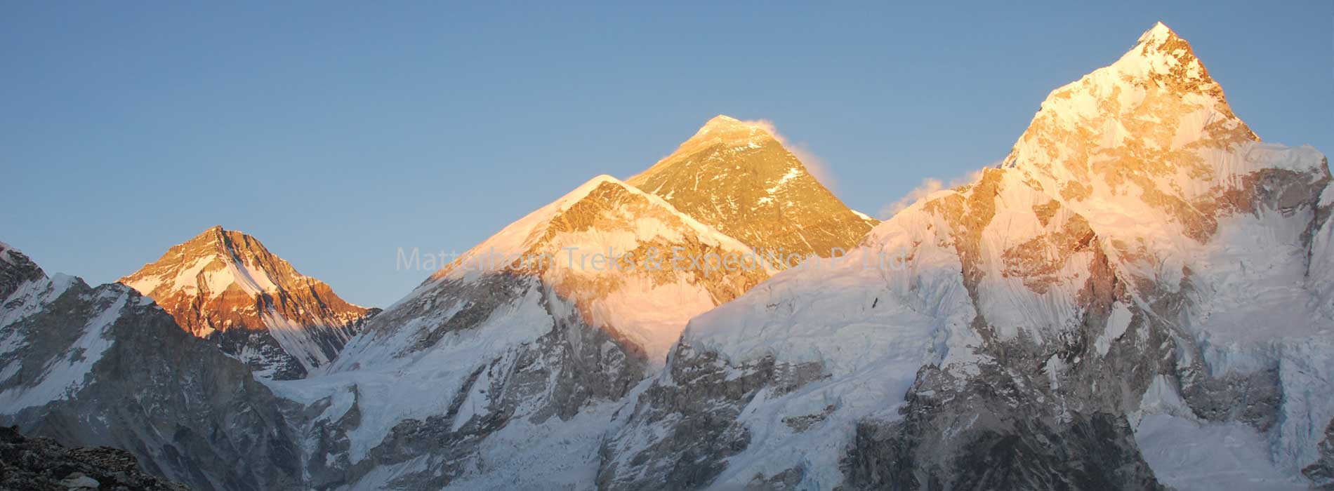
Mount Everest is the highest mountain in the world at 8848m/29,028 ft. or 5 ½ miles above the sea level! Mount Everest is located on the border between Nepal and Tibet. Everest was named after Sir George Everest, the British surveyor-general of India. Everest is known in Tibet as Chomolungma and in Nepal as Sagarmatha. The first people to reach the summit of Everest were the Late Tenzing Norgay and the Late Sir Edmund Hillary, via the South-East Ridge Route on the 29th May 1953.In 1975, Junko Tabei (Japan) was the first woman to reach the summit via the South-East Ridge.
The Southeast ridge begins with a trek to Base Camp at 5,380 m (17,700 ft) on the south side of Everest in Nepal. Expeditions usually fly into Lukla (2,860m) from Kathmandu and pass through Namche Bazaar. Climbers then hike to Base Camp, which usually takes eight to ten days, allowing for proper altitude acclimatization in order to prevent altitude sickness (AMS). Climbing equipment and supplies are carried by yaks, dzopkyos (yak hybrids) and human porters to Base Camp on the Khumbu Glacier.
Day 01 Arrival in Kathmandu
Arrival in Kathmandu Tribhuvan International Airport, a representative from Matterhorn Treks & Expedition will transfer to your hotel, We will brief about your trip activities. You’ll have rest of the day at leisure.
Overnight at Hotel B/B.
Day 02 Kathmandu Sightseeing
Sightseeing in Some of landmarks that are the World Heritage Sites of Kathmandu Durbar Square, the sacred Hindu temple of Pashupati Nath, the famous ‘Monkey Temple’ (Swayambhu Nath) and Buddhists shrine (Bouddha Nath). You can also make your last minute buying of personal items and preparation for the next day.
Overnight at Hotel B/B.
Day 03 Preparation day for the expedition
Overnight at Hotel B/B.
Day 04 Kathmandu – Lukla (2,800 m) – Phakding (2,652 m), 35 min flight, 3- hours trek
Early morning after breakfast, we get transferred to domestic airport and fly to Lukla. After an adventurous 40 minutes flight above breathtaking green and white mountains, we reach Tenzing-Hillary Airport at Lukla. This is one of the most beautiful air routes in the world culminating in a dramatic landing on a hillside surrounded by high mountains peaks. At the airport, we meet our other crew members. We get time to stroll around while the guide divides and manages baggage to be carried by porters. We start our trek through the prosperous village of Lukla until we reach Phakding. To assist in acclimatization, we only have a short hike today. However, if interested in additional activities, take a side trip to a nearby monastery.
Overnight in lodge on full board.
Day 05 Phakding -Namche Bazaar (3,440 m), 5-6 hrs
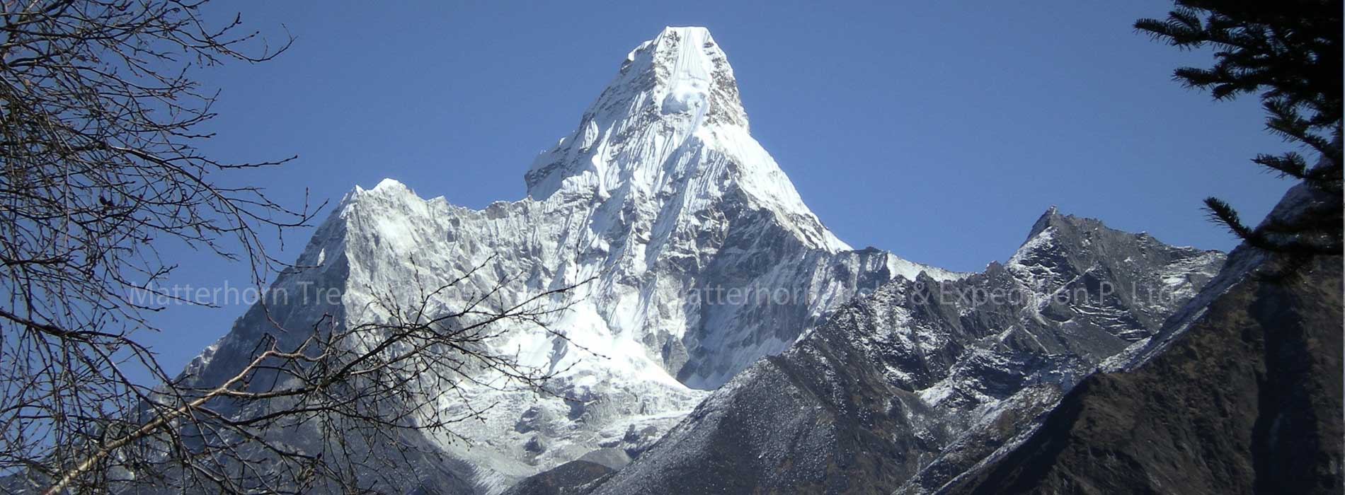
Trek starts in the morning after breakfast. The walk today is pleasant with few short uphill and downhill with multiple crossings over Dudh Koshi River and magnificent view of Mt. Thamserku (6,608 m/21,675 ft) from the Benkar village. Cross some more bridges and reach the entrance of Sagarmatha National Park at Monjo, where our trekking permits are checked in order to keep record of trekkers and local trekking staffs as well. A descend and a gradual walk brings us to Jorsale, the last village until Namche Bazaar. The walk is enjoyable through the river bed and we reach Hillary Suspension Bridge. Now, as we climb up hill towards Namche Bazzar, closer and magnificent sight of Kwangde Peak, its sister peaks, Kusum Kangaru, Mt. Everest, Lhotse, Tawache, and many other fabulous mountains are viewed closer, we stop at the Chautara here to admire the view. Finally, we reach the colorful village of Namche Bazzar, the main gateway of Khumbu region.
Overnight in lodge on full board.
Day 06 Namche Bazaar Acclimatization Day
This is first scheduled ‘acclimatization’ day for this trek. Health experts always recommend us to stay active and moving during the rest day too instead of being idle. We either spend the day taking a day hike to Thame or visiting Khunde or carry out relaxed exploration of Namche Bazaar itself. Namche Bazzar is the main center of the Everest (Khumbu) region and has government offices, ATMs, Internet cafes, shops, restaurants, a bakery and a colorful market each Friday evening and Saturday. If we trek a few hundred vertical feet during the day, it will help us to properly acclimatize. Visit the Tourist Visitor Center near the Sagarmatha National Park headquarters and observe an assortment of things related to the first Everest ascenders, Sherpa culture and learn about the various plant and animal life of the Everest region. We also take an interesting side trip up to Khumjung and climb up to famous airstrip at Syangboche. Just above the airstrip is the Everest View Hotel, a Japanese scheme to build a deluxe hotel with great views of the highest mountains on Earth. The Khumjung valley surrounded by the snowy peaks of Kongde and Thamserku and the sacred peak of Khumbila hosts a well known monastery that houses a yeti scalp. Visit Hillary School which is at the same site. After having lunch and spending some time in Khumjung, walk back down to Namche Bazzar.
Overnight in lodge on full board.
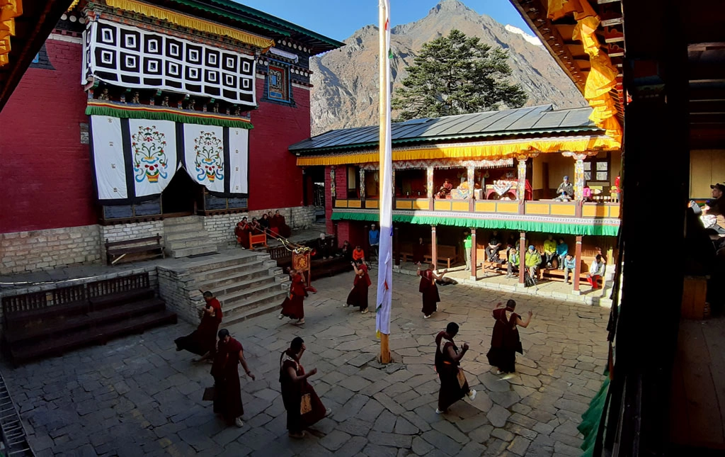
Day 07 Namche to Thyangboche Monastery, 5/6 Hours
From Namche, the well-worn Everest trail contours around the side of the valley high above the Dudh Kosi. As we follow the path, we will get even better views of the great peaks of the Khumbu: Everest, Lhotse, Nuptse and Ama Dablam. Passing by several villages and numerous tea shops, we will cross the Dudh Kosi river and make a steep climb to Thyangboche, home of the famous and recently rebuilt monastery. We have plenty of time to look around Thyangboche, the monastery and have a cake at the bakery before dropping down to the river and the village of Deboche (3,700 m/12,135 ft) a little further along the trail, where we will stay in a relaxing lodge.
Overnight at Lodge on full board.
Day 08: Tengboche trek to Dengboche (4320m), 5 hrs
Descend form Tengboche and again cross the Imja Khola, then side-hill gradually to Pangboche, an interesting gompa site above the main village. The trekkers are in the midst of the Himalayas here with spectacular views all around. For acclimatization, there is a need to spend two nights around the 1400’/4268m level and Dingboche lying in a shelter spot above the Imja Khola is generally more attractive than Pheriche. It is however of note that the Himalayan Rescue Association have their aid post at Pheriche.
Day 09: Dengboche trek – to Island peak base camp(5200m), 4 hours
The path from Chhukung leads fairly steep way climbing south then turning east to the main line of the valley.It then winds along or below the southern flank of the moraine from the Lhotse Glacier. Continue short pleasant walking along a streamside leads to what we call Big- rock. The route to the Amphu Lapcha lies to the south–east. A crisis cross route through the Imja and Lhotse glacier moraines leads to wide valley flanking the SW side of Island peak.
Overnight in Island Peak Base Camp on full board.
Day 10: Island Peak Base Camp to Summit Island Peak & back to Chhukung(6189m), 10 hours
Island Peak Ascent , from early in the morning will have to climb the rock gully.This is not difficult but there are several short rock steps to climb before you emerge on the right side of the gully. The route then follows a ridgeline, which leads to an exhilarating and exposed traverse onto the shout of the summit glacier. You will need to rope up for the glacier as it contains several crevasses but it leads without difficulty, to a 100m snow and ice slope(40-45A) on which guides will fix a rope. From the top of this slope, 3 rope lengthe along a sharp summit ridge lead to the top. After enjoying the summit views you will descend all the way to chhukung .Overnight on full board.
Day 11: Chhukung – Lobuche (4930m. ): 6-7 hrs.
The valley begins to narrow as we pass through Dusa, the yak herders place and Phulung Karpo. We walk up a small ridge and then contour round the base of the Khumbu Glacier. From here, we take a short steep climb to the terminal moraine of the glacier from where the views are stunning. We Arrive at Lobuje (4,930 m).
Day 12: Lobuche – Everest base camp (5364m., 5 – 6 hrs.)
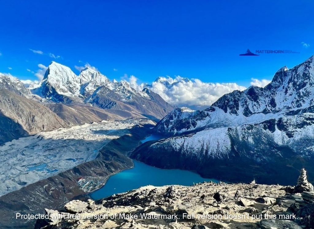
The trail to Gorak Shep goes ahead through the lateral moraine of the Khumbu Glacier with the views of. Everest along with Mt. Pumori, Mt. Mahalangur, Mt. Lingtern, Mt. Khumbutse, Mt. Nuptse, etc. As we reach Gorak Shep, we will find snow-capped mountains looming all around us including Mt. Everest. We further move towards Everest Base Camp and finally we see tents pitched in the vast area of glaciers for Everest and Lhotse expedition members.
Day 13 – 46: Climbing
High camps will be set up above base camps and the climbers will have enough acclimatization going over the high camps, spending the nights there and take rest at the base camp of even below to Lobuche for few nights to get warmer and wait for the better weather for the final summit. Above base camp, Khumbu Ice Fall is crossed in the fixed lines and the aluminum ladders to the plateau of the Western Cwm at camp 1, Camp 2 is located at 6200m. The route from camp 1 traverses the flattish bottom of the Western Cwm and leads to the rocky moraine below the west –face of Everest.
From camp 2, Lhotse face is climbed initially on 40 – 65 degrees slope initially and then easy slope of 30 – 40 degrees which leads to a flattish section protected by solid ice walls at about 7200m. camp 3. Camp 4 is located at 8000m. at an airy perch which requires climbing Lhotse wall crossing short snow field route that finally moves ahead to the east before finishing the flats of South Col. Summit attempt – The route to the summit winds through snow, ice and rock fields and in some stretches exposed rocks to the Hillary Step, a small vertical pitch climbed on fixed ropes which leads to 10 – 20 degree slope and finally to the summit.
Day 47 – 51: Retrace to Lukla.
After successfully summiting the Everest return to Lukla.
Day 52: Flight from Lukla – Kathmandu
Fly to Kathmandu in the morning and relax in Kathmandu transfer to hotel.
Day 53: Extra day incase of bad weather
Day 54: Kathmandu
This pleasant day you may have full day at leisure at your own or can be extends your extra trip with us on additional cost or time to explore the Thamel for last day shopping & evening Matterhorn Treks & Expedition will take you for Farewell dinner. Overnight at Hotel B/B.
Day 55: Departure from Kathmandu
Matterhorn treks & Expedition will transferred to the International Airport your departure flight to your onwards destination.
Día 01: Arribo a Katmandú (1.300 mts)
Llegada al Aeropuerto Internacional Tribhuvan de Katmandú donde un representante de Matterhorn le llevará a su hotel. En este lugar se hará una breve descripción sobre su viaje. El resto del día es libre.
Día 02: Atractivos de Katmandú
Visita a algunos de los principales atractivos que forman parte de los Sitios Patrimonio de la Humanidad de Katmandú como son: Dubar Square, el templo sagrado hinduista de Pashupati Nath, el famoso Monkey Temple (Swayambhu Nath) y el santuario budista de Bouddha Nath.
Día 03: Día de preparación para la expedición
Día 04: Katmandú – Lukla (2.800 mts) – Phakding (2.652 mts)
Temprano en la mañana y después de desayunar se dirigen al aeropuerto local para volar a Lukla. Después de 40 minutos de vuelo sobre verdes valles y blancas montañas se llega al aeródromo Tenzing-Hillary en Lukla. En este lugar se reúnen con el resto de los miembros de la expedición.
Se inicia el trek a través de la próspera aldea de Lukla hasta alcanzar Phakding después de una caminata de aproximadamente 3 horas.
Día 05: Pakhding – Namche Bazaar (3.440 mts)
El trek se inicia tras el desayuno. El camino hoy es agradable con algunos cortos ascensos y descensos con múltiples cruces al río Dudh Koshi y espectaculares vistas del monte Thamserku (6.608 mts) desde la villa de Benkar. Posteriormente se llega a la entrada del Parque Nacional Sagarmatha en la villa de Monjo, donde los permisos de trekking son revisados. Una caminata gradual y en descenso lleva a la villa de Jorsale la última villa antes de alcanzar Namche Bazzar, la principal entrada a la región del Khumbu.
Día 06: Día de aclimatación en Namche Bazaar
Los expertos en Salud siempre recomiendan mantenerse activo durante este día. Por ello se puede visitar la villa de Thame o de Khunde o bien realizar una visita en detalle a Namche Bazaar. Namche Bazaar es el principal centro de la región del Everest, contando con oficinas gubernamentales, Internet, restaurantes, cafés, panaderías y un colorido mercado cada Viernes por la tarde y Sábado.
También se puede tomar un interesante trek hasta a villa de Khumjung. El valle de Khumjung está rodeado por los picos nevados del Kongde y Thamserku y el pico sagrado del Khumbila. Además se puede visitar la Escuela Hillary. Tras el almuerzo y después de haber conocido Khumjung se vuelve a Namche Bazaar donde se pasa la noche.
Día 07: Namche Bazaar – Monasterio de Thyangboche
Desde Namche se toma el transitado sendero que va por el contorno del valle y arriba del rio Dudh Kosi. El sendero pasa por numerosas villas y múltiples lugares donde se puede tomar un té. Tras cruzar el rio Dudh Kosi y luego de ascender por una escarpada subida se llega a Thyangboche, hogar del famoso y recientemente reconstruido monasterio . En este lugar se contará con suficiente tiempo para visitar los alrededores y también el monasterio. El trek este día toma entre 5 y 6 horas.
Día 08: caminata de Tengboche a Dengboche (4320m), 5 hrs.
Desciende desde Tengboche y cruza de nuevo la Imja Khola, luego asciende gradualmente hasta Pangboche, un interesante sitio de gompa sobre la aldea principal. Los excursionistas se encuentran en medio de los Himalayas aquí con vistas espectaculares a su alrededor. Para la aclimatación, es necesario pasar dos noches alrededor del nivel de 1400 ’/ 4268m, y Dingboche acostado en un lugar de refugio encima de Imja Khola es generalmente más atractivo que Pheriche. Sin embargo, es de destacar que la Asociación de Rescate del Himalaya tiene su puesto de ayuda en Pheriche.
Día 09: caminata Dengboche – al campamento base de Peak Island (5200m), 4 horas
El camino desde Chhukung conduce por un camino bastante empinado que sube hacia el sur y luego gira hacia el este hasta la línea principal del valle. Luego serpentea a lo largo o por debajo del flanco sur de la morrena desde el glaciar Lhotse. Continuar corto y agradable caminar a lo largo de un arroyo conduce a lo que llamamos Big Rock. La ruta hacia el Amphu Lapcha se encuentra hacia el sureste. Una ruta transversal de crisis a través de las morrenas de los glaciares Imja y Lhotse conduce a un amplio valle que flanquea el lado suroeste de la cima de la isla.
Pernocte en Island Peak Base Camp en pensión completa.
Día 10: Island Peak Base Camp a Summit Island Peak y de regreso a Chhukung (6189m), 10 horas
Island Peak Ascent, desde temprano en la mañana, tendrá que escalar el barranco de la roca. Esto no es difícil, pero hay varios escalones cortos para escalar antes de que emerja en el lado derecho del barranco. Luego, la ruta sigue una cresta que conduce a una travesía emocionante y expuesta al grito del glaciar de la cima. Necesitará hacer una cuerda para el glaciar, ya que contiene varias grietas, pero conduce sin dificultad a una pendiente de nieve y hielo de 100 m (40-45 A) en la que las guías fijarán una cuerda. Desde la cima de esta pendiente, 3 cuerdas a lo largo de una cresta de cumbre afilada conducen a la cima. Después de disfrutar de las vistas de la cumbre, descenderá hasta chhukung. Pernocte en pensión completa.
Día 11: Chhukung – Lobuche (4930m.): 6-7 hrs.
El valle comienza a estrecharse a medida que pasamos por Dusa, el lugar de los pastores de yak y Phulung Karpo. Subimos por una pequeña cresta y luego hacemos un contorno alrededor de la base del glaciar Khumbu. Desde aquí, subimos una pequeña subida empinada hasta la morrena terminal del glaciar desde donde las vistas son impresionantes. Llegamos a Lobuje (4.930 m).
Día 12: Lobuche – campamento base del Everest (5364m., 5 – 6 hrs.)
El sendero hacia Gorak Shep avanza a través de la morrena lateral del glaciar Khumbu con las vistas. Everest junto con el monte. Pumori, monte. Mahalangur, el monte. Lingtern, el monte. Khumbutse, el monte. Nuptse, etc. Al llegar a Gorak Shep, encontraremos montañas cubiertas de nieve que se ciernen a nuestro alrededor, incluido el monte. Everest. Seguimos avanzando hacia el Campamento Base del Everest y, finalmente, vemos tiendas de campaña en la vasta área de glaciares para los miembros de la expedición del Everest y Lhotse.
Día 13 – 46: escalada.
Los campamentos altos se establecerán por encima de los campamentos base y los escaladores tendrán suficiente aclimatación en los campamentos altos, pasarán las noches allí y descansarán en el campamento base de Lobuche por algunas noches para calentarse y esperar el mejor clima para la cumbre final. Sobre el campamento base, la Caída de Hielo de Khumbu se cruza en las líneas fijas y las escaleras de aluminio a la meseta de la Cwm Occidental en el campamento 1, el Campamento 2 está ubicado a 6200 m. La ruta desde el campamento 1 atraviesa el fondo plano de la Cwm occidental y conduce a la morrena rocosa debajo de la cara oeste del Everest.
Desde el campamento 2, la cara de Lhotse se sube inicialmente en una pendiente de 40 a 65 grados inicialmente y luego en una pendiente fácil de 30 a 40 grados, lo que conduce a una sección plana protegida por paredes de hielo sólido a unos 7200 m. campamento 3. El campamento 4 se encuentra a 8000m. en una percha espaciosa que requiere escalar el muro de Lhotse cruzando una ruta corta del campo de nieve que finalmente avanza hacia el este antes de terminar los pisos del Collado Sur. Intento de cumbre – La ruta a la cumbre serpentea a través de campos de nieve, hielo y rocas y en algunos tramos expuestos Rocas hacia el Paso de Hillary, un pequeño paso vertical trepó sobre cuerdas fijas que conducen a una pendiente de 10 a 20 grados y, finalmente, a la cima.
Día 47 – 51: Retroceder a Lukla.
Después de alcanzar con éxito la cima, el Everest regresa a Lukla.
Día 52: Vuelo desde Lukla – Katmandú.
Vuele a Katmandú por la mañana y relájese en Katmandú, traslado al hotel.
Día 53: Día extra en caso de mal tiempo.
Día 54: Katmandú.
Este agradable día puede tener un día completo en su tiempo libre o puede prolongar su viaje adicional con nosotros en un costo adicional o en tiempo para explorar el Thamel para las compras del último día y la tarde Matterhorn Treks & Expedition lo llevará a la cena de despedida. Pernocte en el Hotel B / B.
Día 55: Salida de Katmandú.
Matterhorn treks & Expedition transferirá al aeropuerto internacional su vuelo de salida a su destino en adelante.
Fill up the form below to tell us what you're looking for