OVERVIEW
The Manaslu and Ganesh Himal areas lie in the north of Nepal adjacent to the Tibetan Border and to the east of the Annapurna Region.The main town and access point to the district is Gorkha.
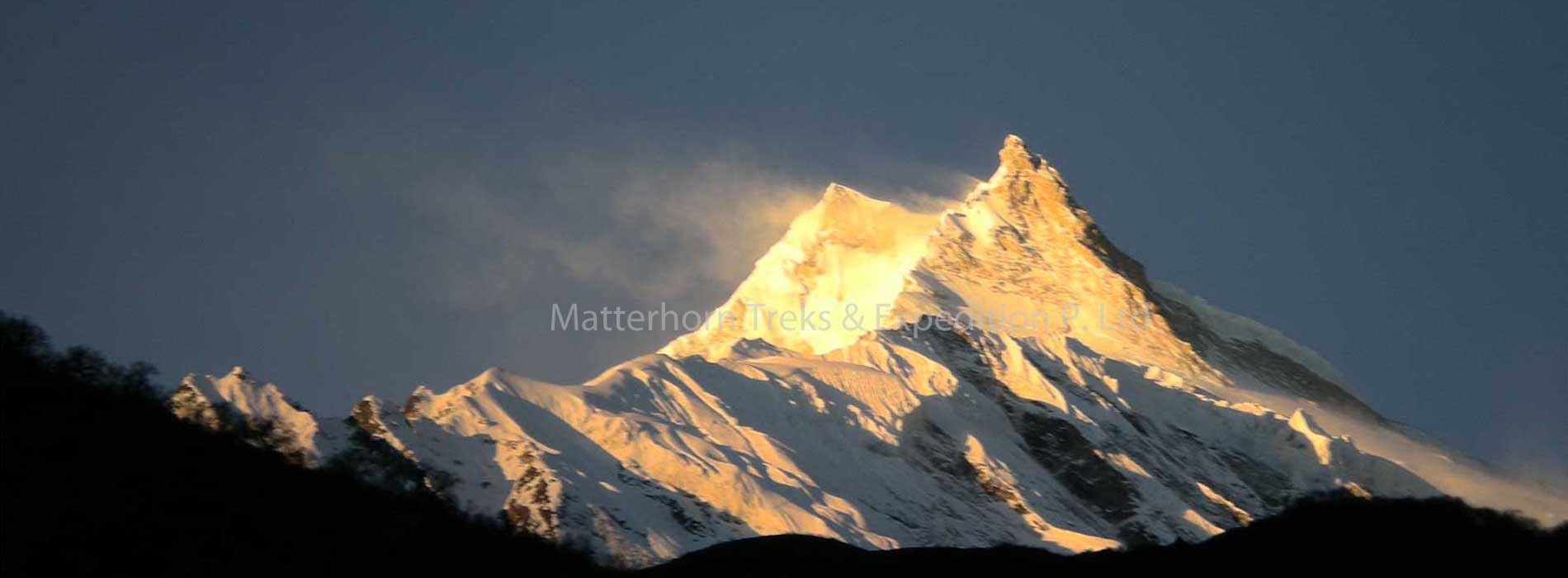
Manaslu is the world seventh highest mountain and has a worthy neighbour in the form of the greater Annapurna range. The area is relatively unknown to trekkers it was only in 1950 that Tilman first visited the area and as such was one of the early Europeans to see Manaslu and its neighbouring peaks.
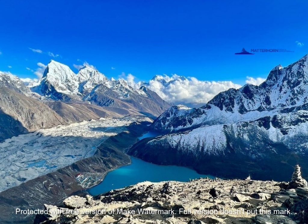
Manaslu and Ganesh Himal appear from a distance as a giant barrier of jagged shimmering mountains hanging above the ground and only attached to the earth by thin slivers of mist. The foothills and lower valleys support ‘paddy’ terraces while water buffalo still play their part in pulling the plough, providing milk and meat. The local homes dotted all around the hillsides are thatched and painted in the traditional manner. Bananas are abundant and cicadas gather in the trees during the blooming season, bringing another dimension to the landscape.
Many regions now provide the traveller with a relatively comfortable and well- serviced experience and the trekker in turn provides Nepal with a much needed income.
However, the trek to Manaslu through the Budhi Gandaki gorge is still a switch-back of continuous and demanding ascents and descents, many of which might pose a few problems to the inexperienced mountain trekker in fact, by some they could be intimidating. However, the views and the apparent close proximity to some of the big Himalayan walls keep the mind focused. This area still provides a adventure to the hardened Himalayan trekker.
ITINERARY
Day 01: Arrival in Kathmandu
Arrival in Kathmandu Tribhuvan International Airport, a representative from Matterhorn Treks & Expedition will transfer to your hotel, We will brief about your trip activities. You’ll have rest of the day at leisure.
Overnight at Hotel B/B.
Day 02: Kathmandu Sightseeing
Sightseeing in Some of landmarks that are the World Heritage Sites of Kathmandu Durbar Square, the sacred Hindu temple of (Pashupati Nath), the famous ‘Monkey Temple’ (Swayambhu Nath) and Buddhists shrine (Bouddha Nath). You can also make your last minute buying of personal items and preparation for the next day.
Overnight at Hotel B/B.
Day 03: Drive to Machha Khola ( 930 m), 9 hrs
You drive along the Kathmandu-Pokhara Highway for the first part of the day and then drive towards the hill bazaar of Gorkha. After Gorkha the road gets a bit rough until reaching Machha Khola.
Stay overnight in camp.
Day 04: Trek Machha Khola to Jagat (1,410 m)
Cross the suspension bridge to the left bank, pass a forested area, then follow the path which looks like it is carved into the rock and you will reach Doban Khola. Trek further along the path across farmed fields and you will reach Jagat, a small village with a police check post and lodges.
Day 05: Trek Jagat to Filim (1590 m)
Leaving the village descend a stone path leading to the wide river shores. Cross the Pangour Khola (flowing from the left) before traversing rapidly and you will reach Saguleri, from where you can see Sringi Himal beyond the valley. Further along the right bank begin ascending until you reach Filim. Though it is a Nepalese Gurung village it has a strong Tibetan influence.
Day 06: Trek Filim to Deng
Leave the village and a small ascending traverse. The trail then goes down to the river shores. Ascend a little while along the Buri Gandaki and cross the suspension bridge to the opposite bank.
Day 07: Deng to Namru (2,630)
Cross to the right bank of the Buri Gandaki using the wooden bridge and more on through houses and farm fields. The path then enters a forested area where Himalayan cedars stand out. More on through the forest and cross over a wooden bridge again. Keep ascending in the forest until you reach Namru.
Day 08: Namru to Lo village (3,150)
The trail begins to descend then ascend until you reach a meadow. After passing the meadow you will enter Bengsam village. Walking through the village the view opens up. Here you can see Naike peak, Manaslu North peak (7,157 m) and the long-awaited Manaslu (8,163 m). The houses in the village are scattered amongst the surrounding farmed fields. Leaving this village and continuing through the Kanni you will reach the Neighbouring Lo village (3,150).
Day 09: Lo village to Sama Gaun (3,500 m)
From Lo village the path descends to the valley of Damonan Khola. Cross the wooden bridge over the stream and climb back up the steep slope. The trail will continue for about 10 minutes along this stream and then fork into two. The path going straight ahead leads directly to Sama (the other which turns to the left will go to Sama via Honsan ho Gompa. From Honsan ho Gompa it then descends along the stream in the forest before joining the main path). The valley ahead of you soon opens wide and you will descend to a wide, flat meadow where Yaks are left to graze.
Day 10: Sama Gaun (Rest day for acclimatization)
You can visit Sama Gompa in about 20 minutes from this village. The gompa, located on top of the hill, is well worth visiting. After passing the gompa there is a wide, grassy area of land from where you can see Manaslu (best in evenings and in the mornings). So beautiful that you may think you are in another world.
Day 11: Sama Gaun to Samdu/Dharmasala
Descend to the Buri Gandaki, which has now turned north again, and follow it to a bridge over a side stream. Take the trail to the left which leads to Manaslu base camp. When you enter the meadow from the path on the river shores you will reach Kermo Kharka, looking up at Manaslu right in front of you. The valley is narrows gradually and the path traverses up to the flank. Follow the path down on the gentle flank and ascend again.
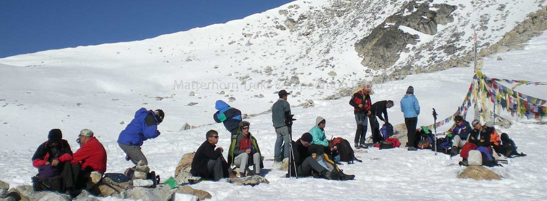
Day 12: Dharmasala to Larkya La/ Bimtang (3720 m)
Today’s route begins up the ridge in front of the guest house which eventually becomes a long gentle climb beside a moraine. The trail here becomes rougher and indistinct as it crosses the moraine to the south of a steep grassy slope. It takes 3 to 4 hrs from the guest house to the pass and is extremely cold and windy climbing on the Larkya La in snowstorms. The descending trail follows along the top of a moraine to the west, then drops steeply and traverses scree slopes. It makes a long set of steep, rough, switchbacks, crosses the moraine and then descends more gently. The trail improves before you reach a large meadow, a main wall and a small rest house. The place here is called ‘Bimtang’, which is a Tibetan name meaning ‘plain of sand.’
Day 13: Bimtang to Tilje
The trail drops from the Bimtang meadow and crosses a glacial stream, the headwaters of the Dudh Khola, by a wooden bridge. Climb over the side of the moraine and descend into a pine and rhododendron forest to Hompuk (3430 m). The walking improves as the trail descends and switches back down to a fork of the Dudh Khola It then follows the river through forests to a got (3030 m). Continue through fields, over a clear stream, passing houses and more fields interspersed with rhododendron and oak forests.
Stay overnight in camp.
Day 14: Tilje to Jagat (1400m)
Cross the wooden bridge to the left bank of the Dudh Khola where the path begins a gentle descent. After about one hour cross the suspension bridge over the Marsyandi River before reach Dharampati (1,860m). we trek continue to Jagat 1300 m.
Day 15: Drive Jagat – Besishahar – Kathmandu. ( 1300 m ) After breakfast we drive to besishahar,then after having lunch we continue drive to Kathmandu. It is a picturesque drive on the way back to Kathmandu along the banks of the Marshyangdi and Trishuli rivers with splendid views of green hills, mountains, farming terraces and colorful villages on both sides of road. Overnight at Hotel B/B.
Day 16: Kathmandu
This pleasant day you may have full day at leisure at your own or can be extends your extra trip with us on additional cost or time to explore the Thamel for last day shopping and evening Matterhorn Treks & Expedition will take you for Farewell dinner.
Overnight at Hotel B/B.
Day 17: Departure from Kathmandu
Matterhorn treks & Expedition will transfer you to the International Airport for your departure flight to your on wards destination.
Día 1: Arribo a Katmandú (1.300 mts)
Llegada al Aeropuerto Internacional Tribhuvan de Katmandú donde un representante de Matterhorn le llevará a su hotel. En este lugar se hará una breve descripción sobre su viaje. El resto del día es libre.
Alojamiento en Katmandú
Día 2: Atractivos de Katmandú
Visita a algunos de los principales atractivos que forman parte de los Sitios Patrimonio de la Humanidad de Katmandú como son: Dubar Square, el templo sagrado hinduista de Pashupati Nath, el famoso Monkey Temple (Swayambhu Nath) y el santuario budista de Bouddha Nath.
Alojamiento en Katmandú
Día 3: Katmandú – Arughat Bazar
La ruta realizada en bus sigue la misma ruta Katmandú-Pokhara en la primera parte para luego dirigirse al bazar de montaña de Gorkha. Después de Gorkha el camino se pone un poco dificultoso hasta llegar a Arughat Bazaar tras unas siete horas de trayecto.
Día 4: Aarughat Bazaar – Soti Khola (810 mts)
El sendero asciende a través de arrozales y campos de cultivo hasta pasar el pequeño caserio de Kokethar. Continuando por un camino nivelado se verá una inmensa roca hacia la izquierda. Luego se llega a Kyoropani tras el cual luego de repetidas subidas y bajadas se arriba finalmente a Soti Khola.
Día 5: Soti Khola – Machha Khola (930 mts)
Desde Soti Khola y pasando por Lapubesi se atraviesa una pendiente formada por arrozales. El sendero luego desciende a orillas de arenas blancas para volver de nuevo al flanco de la montaña. Tras esto, en una hora aproximadamente se llega a Machha Khola.
Día 6: Machha Khola – Jagat (1.350 mts)
Cruzando el puente en suspensión hacia la orilla izquierda se pasa por una área boscosa que sigue un sendero el cuál pareciera haber sido tallado en la roca hasta llegar Doban Khola. Luego, el sendero sigue a través de tierras cultivables para llegar a Jagat, una pequeña villa con un puesto de policía y algunos alojamientos.
Día 7: Jagat – Filim (1.590 mts)
Dejando la villa de Jagat, el sendero desciende por una camino de piedra que lleva a la orilla de un ancho río llamado Pangour. Al cruzarlo, rápidamente la travesía llega a Saguleri, desde donde se puede ver Singri Himal más allá del valle. Adelante siguiendo la orilla derecha del río se inicia el ascenso hasta alcanzar Filim, que aunque es una villa Gurung tiene una fuerte influencia tibetana.
Día 8: Filim – Deng
Dejando la villa de Filim, el sendero presenta un pequeño ascenso para luego descender hasta la orilla del río Buri Gandaki, para luego ascender un poco y cruzar el puente en suspensión para llegar a Deng.
Día 9: Deng – Namru (2.630 mts)
Cruzando a la orilla derecha del río Buri Gandaki a través de un puente de madera, se sigue el camino a través de tierras cultivables. El sendero luego entra en una zona boscosa donde el cedro del Himalaya destaca. Siguiendo por el bosque y cruzando el río de nuevo por un puente de madera se sigue ascendiendo hasta llegar a Namru.
Día 10: Namru – Lo Village (3.150 mts)
El sendero empieza a descender y luego a ascender hasta llegar a una pradera. Tras pasar la pradera se entra en la villa de Begsam. Caminando a través de la villa empiezan a aparecer las vistas de montaña . Aquí se podrá ver el Naike Peak, el Manaslu North Peak (7.157 mts) y el Manaslu (8.163 mts). Abandonando la villa y siguiendo el sendero a través de Kanni se llega finalmente a Lo Village.
Día 11: Lo Village – Sama Gaun (3.500 mts)
Desde Lo Village el camino desciende hasta el valle del río Damonan para subir de nuevo por una empinada pendiente. El sendero luego continúa por unos 10 minutos siguiendo el curso del río para luego bifurcarse en dos. El camino que va derecho adelante lleva directamente a Sama (el otro que gira a la izquierda llegará a Sama vía Honsan ho Gompa. Desde Honsan ho Gompa el sendero desciende a lo largo de río por el bosque antes de unirse al camino principal). El valle adelante pronto se abre ampliamente y se inicia el descenso a una amplia y plana pradera donde los yaks son dejados pastando.
Día 12: Sama Gaun
Este es un día de descanso y aclimatación. Se puede visitar Sama Gompa a 20 minutos desde la villa. La Gompa se ubica en la cima de un cerro y bien vale la pena visitarla. Después de pasar la Gompa hay un amplio y herboso terreno desde donde se puede ver el Mt Manaslu.
Día 13: Sama Gaun – Samdu/Dharmasala
Descendiendo hasta el río Buri Gandaki, el cual ha girado al norte de nuevo, y siguiéndolo hasta llegar a un puente, se toma el sendero hacia la izquierda el cual lleva al campamento base del Manaslu. Cuando se entra a la pradera desde el camino sobre la orilla del río se llega a Kermo Kharka con una vista del Manaslu que se erige justo en frente. Después de pasar Kermo Kharka, el valle se va estrechando gradualmente y el camino desciende y asciende nuevamente.
Día 14: Dharamsala – Larkya La/Bimtang (3.720 mts)
El sendero parte ascendiendo la cresta frente a la villa, transformándose en un largo y suave ascenso por el lado de la morrena. Luego el sendero se hace más difícil. Se toma de 3 a 4 horas llegar desde la villa al paso Larkya La. El camino de descenso desde el paso sigue a lo largo de la cima de la morrena hacía el oeste, luego desciende abruptamente y atraviesa pendientes pedregosas. Luego el sendero hace un largo conjunto de empinados y asperos cruces a la morrena para luego descender más suavemente. El sendero mejora antes de llegar a una amplia pradera, una muralla y un pequeño alojamiento. El lugar aquí es llamado Bimtang, lo que en tibetano significa “llanura de arena”.
Día 15: Bimtang – Tilje
El sendero desciende desde la pradera de Bimtang y cruza el torrente del glaciar, el que es la cabecera del río Dudh, a través de un puente de madera. Ascendiendo sobre un costado de la morrena y luego descendiendo a un bosque de pino y rododendros se llega a Hompuk (3.430 mts). El camino mejora mientras desciende y retrocede hasta una bifurcación del río Dudh. Luego sigue la ruta del río por bosques hasta Goth (3.030 mts). Continúa el sendero través de campos, torrentes cristalinos, casas dispersas y bosques hasta llegar a Tilje.
Día 16: Tilje – Jagat
Cruzando el puente de madera hacia la orilla izquierda del río Dudh, el sendero inicia un suave descenso. Después de una hora se cruza el puente en suspensión sobre el río Marsyandi antes de llegar a Dharampati, para luego seguir hasta Jagat.
Día 17: Jagat – Bahundanda
Después de desayunar se emprende el camino a Bahundanda pasando por la villa de Ghermu y siguiendo el paso a través de campos de arroz. Se cruza otro puente en suspensión sobre el río Syange antes de alcanzar Bahundanda.
Día 18: Bahundanda – Besishahar
El camino cruza a través de campos de terrazas y pequeños arroyos para llegar a Besishahar.
Día 19: Besishahar – Katmandú
Por un pintoresco camino junto a los cursos de los ríos Marshyangdi y Trishuli se conduce de vuelta a Katmandú. Además en el camino se tienen esplendidas vistas de colinas verdes, montañas, terrazas de cultivo y coloridas villas a ambos lados del camino.
Día 20: Katmandú
Día de relajo para explorar Thamel y realizar las últimas actividades. Por la tarde Matterhorn Treks & Expeditions organiza una cena de despedida.
Alojamiento en Katmandú
Día 21: Partida desde Katmandú
Matterhorn Treks & Expeditions transporta cada pasajero al Aeropuerto Internacional para la toma de los respectivos vuelos que lo llevarán a su destinación.
Fill up the form below to tell us what you're looking for